Understanding Drought
Drought is a prolonged period of below-average precipitation that reduces water availability in soils, rivers, reservoirs, and groundwater. In New Mexico's semi-arid climate, drought is a recurring condition that can affect water supplies, agriculture, ecosystems, and communities.
Drought conditions are commonly described based on the type of impacts observed. These drought indicators help track changes in climate and water supply conditions across New Mexico.
Why multiple indicators matter
Drought develops differently across weather, water supply, land conditions, ecosystems, and communities, so no single dataset tells the whole story.

Meteorological Drought
Periods of significantly below-normal precipitation.

Agricultural Drought
When soil moisture is insufficient to support crops and vegetation.
Hydrological Drought
Reduced streamflows, reservoir storage, snowpack, and groundwater levels.
Socioeconomic Drought
When water shortages begin to affect communities, economies, and public well-being.
Ecological Drought
When reduced water availability stresses ecosystems and natural habitats.
Monitoring Multiple Indicators
No single indicator fully describes drought conditions. This page brings together key monitoring tools used to understand climate, hydrologic, and water supply conditions across New Mexico.
Drought monitoring tools combine remote sensing, ground-based observations, and indices to track, assess, and provide early warnings for drought conditions
Indicators are displayed as interactive maps, charts, or linked data dashboards.
Streamflow
USGS streamflow gauges track river flows across the state and help show changing runoff and water availability conditions.
Reservoir storage data helps track water supply conditions and storage trends across key systems.
Data source: U.S. Geological Survey streamflow gauges.
View full mapPrecipitation (ZiaMet Network)
Precipitation observations from the ZiaMet weather stations provide near real-time rainfull data from monitoring stations across New Mexico.
Data source: New Mexico State University(NMSU)
View ZiaMet Data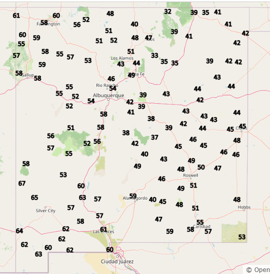
Bureau of Reclamation Reservoir Basins
These basin graphics provide a quick look at key reservoir systems managed by the Bureau of Reclamation in and around New Mexico.
Data source: U.S. Bureau of Reclamation.
View Bureau of Reclamation Basins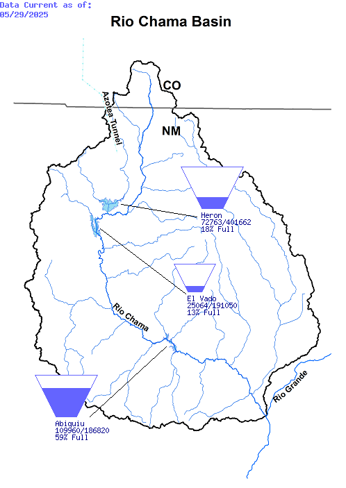
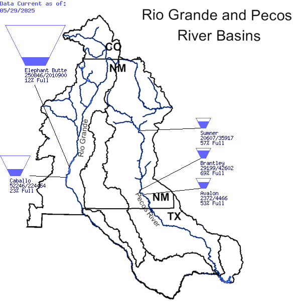
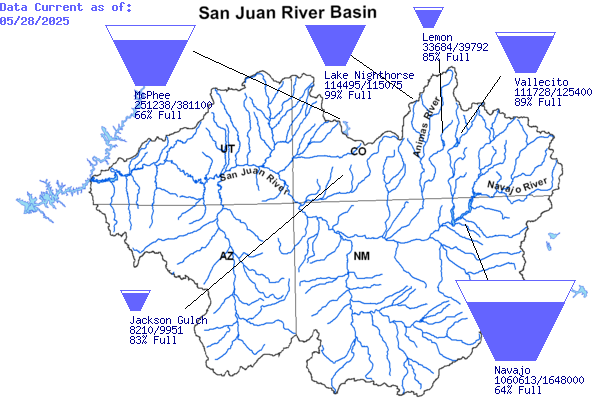
Courtesy of the U.S. Department of the Interior Bureau of Reclamation.
PRISM Climate Data
The PRISM Group gathers weather observations from a wide range of monitoring networks, applies sophisticated quality control measures and mapping methods, and develops spatial datasets to reveal short- and long-term weather patterns.
Data Source: PRISM Climate Group, Oregon State University
Visit PRISM websiteSnowpack Conditions (NWCC iMap)
The NWCC iMap provides interactive maps of snowpack, precipitation, and climate conditions across the western United States. These maps help track snowpack conditions and water supply trends that influence drought.
Data Source: NRCS National Water and Climate Center (NWCC)
NWCC iMapSnowpack Time Series (AWS Plot)
AWS plots display time series data from snow monitoring stations, showing changes in snow water equivalent over time. These graphs help track how snowpack conditions evolve throughout the winter season.
Data Source: NRCS / Snow Telemetry (SNOTEL)
AWS PlotSoil Moisture & Land Surface Conditions (SPoRT Viewer)
The SPoRT Viewer provides satellite-based maps of soil moisture and land surface conditions. These data help identify areas experiencing unusually dry soils that may contribute to drought development.
Data Source: NASA Short-term Prediction Research and Transition (SPoRT)
SPoRT Viewer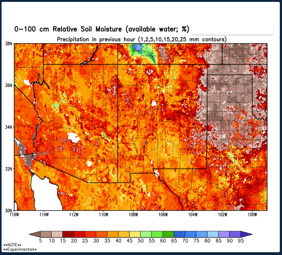
Western Water Supply Forecasts
Seasonal water supply forecasts estimate expected streamflow during the spring and summer runoff season. These forecasts help water managers anticipate water availability for reservoirs, irrigation, and drought planning.
Data Source: USDA NRCS - Water and Climate Center
Western Water Supply Forecasts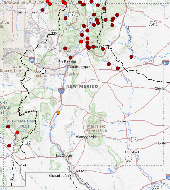
OSE Real-Time Water Measurement System
Through Active Water Resource Management, the OSE/ISC maintains stream, acequia, ditch, and well monitoring sites that transmit data electronically for public use.
Data source: State Of New Mexico AWRM and RTWMS.
Fire Information
Drought and wildfire risk are linked. Dry conditions lead to increased fuel (dry grass, dead trees, etc.). Additionally, weather patterns (wind, low humidity, low precipitation) during a drought often enhance wildfire risks. Please visit the following resources for more information.
NM Fire Info | Fire RestrictionsData source: New Mexico Energy, Minerals and National Interagency Fire Center.